Outdoors
-
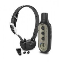
Delta Sport XC
$219.99Simple and Effective Electronic Dog Training in Your Hands
- Intuitive 3-button hand held controller with easy to read LCD and built-in BarkLimiter™
- 36 levels of momentary and continuous stimulation plus tone and vibration
- Changeable/replaceable contact points — long and short
- 5 correction configurations for different behavioral issues
- Train 1, 2 or 3 dogs, settable on the handheld (with purchase of additional dog devices)
-
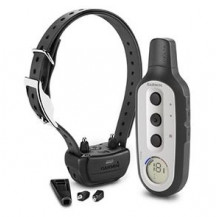
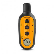
Delta XC
$169.99Simple and Effective Electronic Dog Training in Your Hands
- Intuitive 3-button handheld controller unit with easy-to-read LCD display
- 18 levels of momentary and continuous stimulation plus tone and vibration
- Changeable/replaceable contact points — long and short
- 3 correction configurations for different behavioral issues
- Train 1, 2 or 3 dogs, settable on the handheld (with purchase of additional dog devices)
-

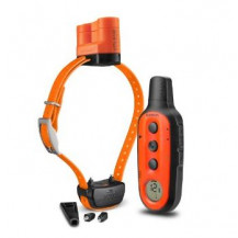
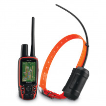
Alpha Bundle (Alpha 100 and TT 15 Dog Device)
$799.99Multi-Dog Tracking GPS and Remote Training Device in One
-
Tracks up to 20 dogs or buddies from up to 9 miles (TT 15) or 4 miles (TT 15 mini) away
-
18 training levels of continuous and momentary stimulation
-
Tone and vibration alerts
-
Preloaded TOPO U.S. 100k maps
-
Measures dog' speed and distance traveled
-
-
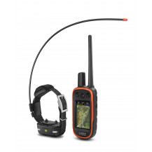
Alpha Mini Bundle (Alpha 100 and TT 15 mini Dog Devices)
$799.99Multi-dog Tracking GPS and Remote Training Device in One
-
Tracks up to 20 dogs or buddies from up to 9 miles (TT 15) or 4 miles (TT 15 mini) away
-
18 training levels of continuous and momentary stimulation
-
Tone and Vibration alerts
-
Preloaded TOPO U.S. 100k maps
-
Measures dogs' speed and distance traveled
-
-
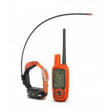
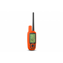
Astro Bundle (Astro 320 and T 5 Dog Devices)
$599.99Premier Tracking System for Sporting Dogs
-
Track up to 10 dogs at a time, up to 9 miles (T 5) and 4 miles (T 5 mini) away
-
T 5 or T 5 mini dog devices with top-mounted high-sensitivity GPS / GLONASS transmitter with flexible braided steel antenna
-
Compatible with TT 15 and TT 15 mini dog devices and collars (for tracking only)
-
Advanced mapping with optional BirdsEye Satellite Imagery and TOPO maps
-